I began chasing thunderstorms in the fall of 2009. Over the course of the last three and a half years, I have seen some amazing phenomenon, but the one that always eluded me was a high contrast, photogenic tornado.
Three and a half years, and twenty thousand miles on the road later, I finally found what I had been looking for all this time. My first tornado. We were on the storm from the time it was a few small cumulus clouds, and we tracked it for approximately an hour before the first tornado touched down. From a storm chaser's perspective, it was pretty much the perfect first tornado. It sat nearly stationary in a field, staying on the ground for an hour, and at one point, backtracking to the west.
On the morning of May 28th, we awoke at our hotel in Salina, Kansas. The models were showing a very marginal setup, with not much of a chance of tornadoes. The Storm Prediction Center had our area in a slight risk for severe weather, with a 5% chance for tornadoes (although they did later upgrade to a moderate risk). We discussed where to target for the day, and after some debate, decided to stay put in Salina. I had said that Northeast Kansas could produce something as well, and sure enough, by mid afternoon, there was a large supercell, with a very pronounced hook echo, and a confirmed tornado on the ground north of Topeka. An hour and a half away, we knew we had no chance of making it to that storm, and decided to stick to our original plan, and stay put as a cumulus field began to develop over the Salina area.
The storm quickly organized into a severe thunderstorm, and we moved to the northwest on Highway 81 to get closer. We sat on a hilltop, before moving slightly further west, near highway 18. The storm began showing signs of rotation, with a pronounced lowering near the southern edge of the supercell. As the storm organized further, we headed towards the storm on Highway 18, as a wall cloud quickly developed into a small, rope funnel.
The first funnel lasted just a couple of minutes before roping out, as the supercell began to cycle and become stronger. The now tornado warned storm began to wrap up into a tight mesocyclone, which began to rapidly rotate and produce a brief, spinup tornado.
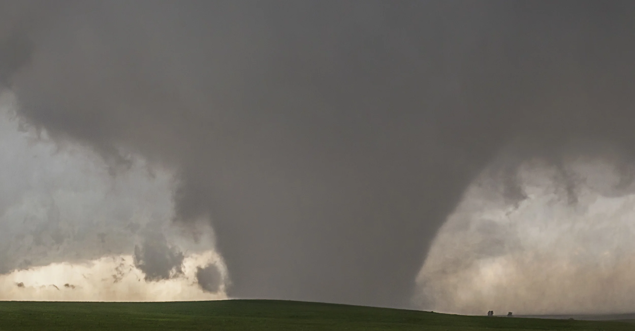
Rain began to wrap around the southern edge of the supercell, so we decided to get in the car and move back east about 1/4 mile. This would prove to be our only big mistake of the day, because by the time we all got in, and looked back out the window, a large cone funnel was about 3/4 of the way to the ground. There it was! MY FIRST TRUE TORNADO! No ifs, ands, or buts...there it was, about to be on the ground, NOW!
The tornado quickly grew into a violent, multivortex cone. Due to its rapid expansion, it appeared to me as if the tornado was actually moving towards us, so we made the decision to get back into the vehicle, and head east for a bit, out of the path of the tornado. Savannah kept her eyes on it and urged us to stop, as we quickly put distance between us and what was now actually a nearly stationary stovepipe tornado.

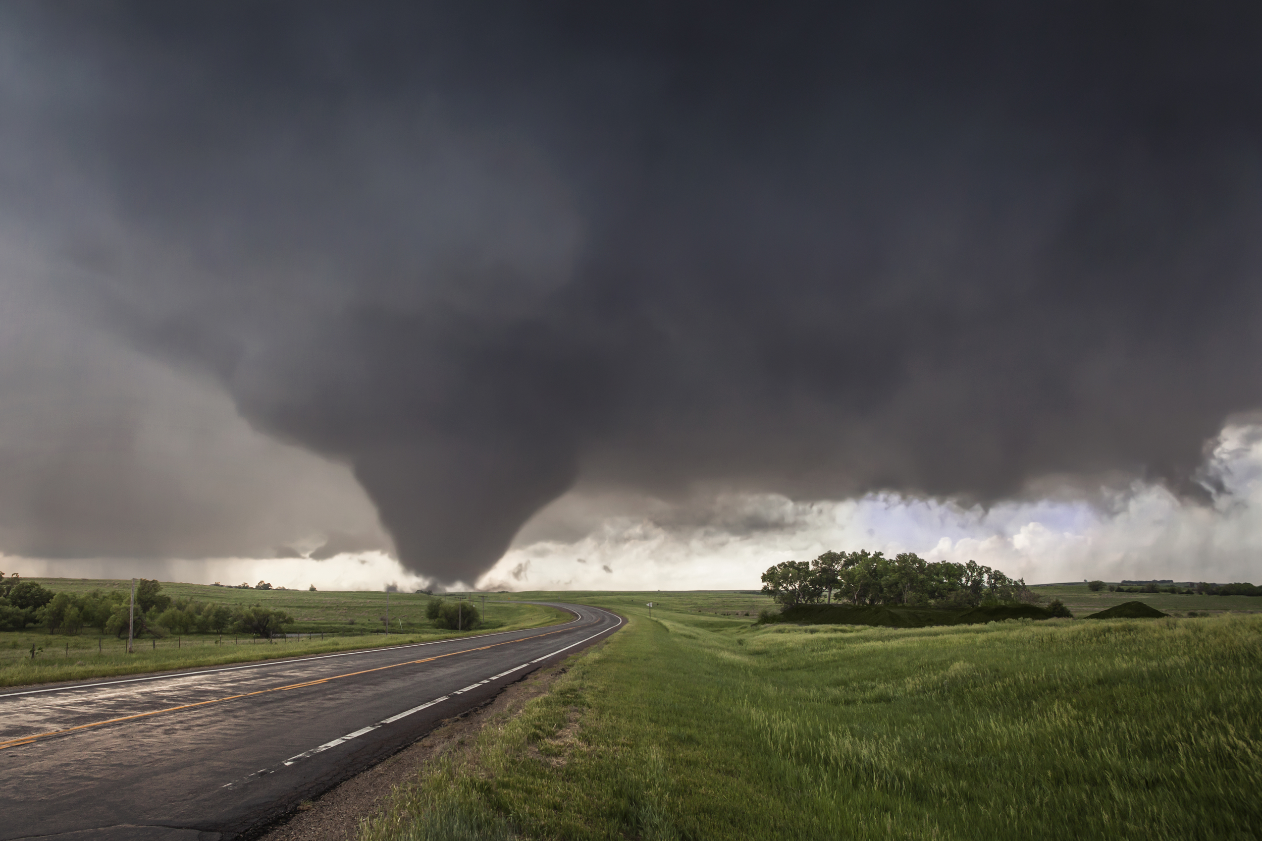
We stopped along Highway 18, as storm chasers and locals began to descend on the area, to take in the site of a beautiful high contrast tornado plowing through the open fields of rural Kansas. It all felt like a dream, but it was an experience none of us will soon forget.
Since we were so close to the tornado, and because the storm was not causing mass damage or casualties, we found it appropriate to pose for several shots in front of the tornado. These will certainly be in the family album.

The tornado, at its strongest, widest point was an EF-4 wedge tornado. It should be noted that the DOW (Doppler On Wheels) truck did measure winds of 247mph, that would have rated this tornado an EF-5. However, since the tornado hit few structures, and caused minimal damage, its official rating by the National Weather Service was EF-4.
This tornado showed us just about every form they can come in; cone, stovepipe, and wedge. It was ever changing, a fascinating learning experience, and was arguably the tornado of the year. This stage of the tornado was by far my favorite. I'm not an expert on tornado classification, but this was kind of a cone stage, between it being a wedge, and then quickly transitioning from a stovepipe to a rain wrapped wedge. We watched the storm for a while after it went rain wrapped, the tornado occasionally popping out of the rain to offer us a brief glimpse, then disappearing again.
We tried to pursue the storm, but due to its destructive power and low visibility, we decided to watch from a few miles back on a hilltop. I couldn't have asked for a better first tornado. I always said I wanted my first to be a monster in an open field, and I got that exact wish. The storm caused no human fatalities, although it is estimated to have killed 100 cattle during its lifecycle. Five homes also sustained damage, one majorly, along with numerous destroyed power lines and farm equipment.
I hope you enjoyed my first tornado chase account.
As always, comments and questions are welcome, and I will do my best to answer them in a timely manner.